• Wyszukiwanie zaawansowane
  • Kategorie
  • Kategorie BISAC
  • Książki na zamówienie
  • Promocje
  • Granty
  • Książka na prezent
  • Opinie
  • Pomoc
  • Załóż konto
  • Zaloguj się

Pyrenees and Andorra Map » książka

zaloguj się | załóż konto
Logo Krainaksiazek.pl

koszyk

konto

szukaj
topmenu
Księgarnia internetowa
Szukaj
Książki na zamówienie
Promocje
Granty
Książka na prezent
Moje konto
Pomoc
 
 
Wyszukiwanie zaawansowane
Pusty koszyk
Bezpłatna dostawa dla zamówień powyżej 40 złBezpłatna dostawa dla zamówień powyżej 40 zł

Kategorie główne

• Nauka
 [2952531]
• Literatura piękna
 [1815254]

  więcej...
• Turystyka
 [52246]
• Informatyka
 [151406]
• Komiksy
 [36554]
• Encyklopedie
 [23115]
• Dziecięca
 [612095]
• Hobby
 [104900]
• AudioBooki
 [1784]
• Literatura faktu
 [191556]
• Muzyka CD
 [380]
• Słowniki
 [2946]
• Inne
 [442645]
• Kalendarze
 [1505]
• Podręczniki
 [166084]
• Poradniki
 [422936]
• Religia
 [506774]
• Czasopisma
 [518]
• Sport
 [60387]
• Sztuka
 [242639]
• CD, DVD, Video
 [3428]
• Technologie
 [219359]
• Zdrowie
 [98539]
• Książkowe Klimaty
 [124]
• Zabawki
 [2509]
• Puzzle, gry
 [3809]
• Literatura w języku ukraińskim
 [261]
• Art. papiernicze i szkolne
 [8058]
Kategorie szczegółowe BISAC

Pyrenees and Andorra Map

ISBN-13: 9781566955409 / Angielski / Folded / 2022 / 2 str.

National Geographic Maps
Pyrenees and Andorra Map National Geographic Maps 9781566955409 National Geographic Maps - książkaWidoczna okładka, to zdjęcie poglądowe, a rzeczywista szata graficzna może różnić się od prezentowanej.

Pyrenees and Andorra Map

ISBN-13: 9781566955409 / Angielski / Folded / 2022 / 2 str.

National Geographic Maps
cena 58,39
(netto: 55,61 VAT:  5%)

Najniższa cena z 30 dni: 56,04
Termin realizacji zamówienia:
ok. 16-18 dni roboczych.

Darmowa dostawa!

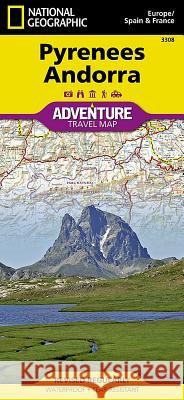
- Waterproof - Tear-Resistant - Travel MapNational Geographic's Pyrenees and Andorra Adventure Map provides global travelers with the perfect combination of detail and perspective in a highly functional travel tool. This map includes the locations of cities and towns with a user-friendly index, plus a clearly marked road network complete with distances and designations for roads and highways. Beaches and yachting harbors dot Spain and France's Mediterranean coastlines while the location of golf courses, camping sites, waterfalls, caves, and ski areas make it easy to enjoy the region's abundant outdoor activities. National parks, World Heritage sites, scenic viewpoints, antiquity sites, museums, and more are included, making it invaluable to travelers hoping to experience all the history, art, and culture the region has to offer.The front side of the print map shows the country of Andorra and the eastern half of the Pyrenees including the cities of Narbonne, Carcassone, Pamiers, St-Gaudens, St-Girons, Perpignan in France, and Balaguer, Manresa, and Figueres in Spain. The reverse side of the map stretches from the city of Biarritz on the Bay of Biscay eastward to include Pamplona and Huesca, Spain, and Pau, Tarbes, and the famed pilgrimage site of Lourdes, France. Popular for alpine skiing and mountaineering, the Pyrenees are a scenic mountain range which form a natural boundary between Spain and France. Stages of two of cycling's epic grand tours - the Tour de France and the Vuelta a Espana - traverse the Pyrenees and three long-distance footpaths run the length of the mountain range. Nestled in the center of the Pyrenees is the ruggedly beautiful Andorra, the sixth smallest country in Europe which is roughly two and a half times the size of Washington, D.C. Its picturesque mountain vistas and easy charm have made Andorra a favorite destination for savvy travelers. Every Adventure Map is printed on durable synthetic paper, making them waterproof, tear-resistant and tough -- capable of withstanding the rigors of international travel.

  • Map Scale = 1:275,000
  • Sheet Size = 37.75- x 25.5-
  • Folded Size = 4.25- x 9.25-

Kategorie:
Turystyka
Kategorie BISAC:
Travel > Maps & Road Atlases (see also Reference - Atlases, Gazetteers & Maps)
Travel > Europe - France
Travel > Europe - Spain & Portugal
Wydawca:
National Geographic Maps
Język:
Angielski
ISBN-13:
9781566955409
Rok wydania:
2022
Numer serii:
000392108
Ilość stron:
2
Waga:
0.09 kg
Wymiary:
22.86 x 10.41 x 1.02
Oprawa:
Folded
Wolumenów:
01
Dodatkowe informacje:
Wydanie ilustrowane
National Geographic Maps Founded in 1915 as the Cartographic Group, the fir... więcej >


Udostępnij

Facebook - konto krainaksiazek.pl


Opinie o Krainaksiazek.pl na Opineo.pl

Partner Mybenefit

Krainaksiazek.pl w programie rzetelna firma Krainaksiaze.pl - płatności przez paypal

Czytaj nas na:

Facebook - krainaksiazek.pl
  • książki na zamówienie
  • granty
  • książka na prezent
  • kontakt
  • pomoc
  • opinie
  • regulamin
  • polityka prywatności

Zobacz:

  • Księgarnia czeska

  • Wydawnictwo Książkowe Klimaty

1997-2026 DolnySlask.com Agencja Internetowa

© 1997-2022 krainaksiazek.pl
     
KONTAKT | REGULAMIN | POLITYKA PRYWATNOŚCI | USTAWIENIA PRYWATNOŚCI
Zobacz: Księgarnia Czeska | Wydawnictwo Książkowe Klimaty | Mapa strony | Lista autorów
KrainaKsiazek.PL - Księgarnia Internetowa
Polityka prywatnosci - link
Krainaksiazek.pl - płatnośc Przelewy24
Przechowalnia Przechowalnia