• Wyszukiwanie zaawansowane
  • Kategorie
  • Kategorie BISAC
  • Książki na zamówienie
  • Promocje
  • Granty
  • Książka na prezent
  • Opinie
  • Pomoc
  • Załóż konto
  • Zaloguj się

Grand Junction, Fruita Map » książka

zaloguj się | załóż konto
Logo Krainaksiazek.pl

koszyk

konto

szukaj
topmenu
Księgarnia internetowa
Szukaj
Książki na zamówienie
Promocje
Granty
Książka na prezent
Moje konto
Pomoc
 
 
Wyszukiwanie zaawansowane
Pusty koszyk
Bezpłatna dostawa dla zamówień powyżej 20 złBezpłatna dostawa dla zamówień powyżej 20 zł

Kategorie główne

• Nauka
 [2948695]
• Literatura piękna
 [1824038]

  więcej...
• Turystyka
 [70868]
• Informatyka
 [151073]
• Komiksy
 [35227]
• Encyklopedie
 [23181]
• Dziecięca
 [621575]
• Hobby
 [138961]
• AudioBooki
 [1642]
• Literatura faktu
 [228651]
• Muzyka CD
 [371]
• Słowniki
 [2933]
• Inne
 [445341]
• Kalendarze
 [1243]
• Podręczniki
 [164416]
• Poradniki
 [479493]
• Religia
 [510449]
• Czasopisma
 [502]
• Sport
 [61384]
• Sztuka
 [243086]
• CD, DVD, Video
 [3417]
• Technologie
 [219673]
• Zdrowie
 [100865]
• Książkowe Klimaty
 [124]
• Zabawki
 [2168]
• Puzzle, gry
 [3372]
• Literatura w języku ukraińskim
 [260]
• Art. papiernicze i szkolne
 [7838]
Kategorie szczegółowe BISAC

Grand Junction, Fruita Map

ISBN-13: 9781566954884 / Angielski / Folded / 2023 / 2 str.

National Geographic Maps
Grand Junction, Fruita Map National Geographic Maps 9781566954884 Not Avail - książkaWidoczna okładka, to zdjęcie poglądowe, a rzeczywista szata graficzna może różnić się od prezentowanej.

Grand Junction, Fruita Map

ISBN-13: 9781566954884 / Angielski / Folded / 2023 / 2 str.

National Geographic Maps
cena 56,98
(netto: 54,27 VAT:  5%)

Najniższa cena z 30 dni: 56,67
Termin realizacji zamówienia:
ok. 30 dni roboczych.

Darmowa dostawa!

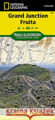
- Waterproof - Tear-Resistant - Topographic MapJam packed with over 500 miles of single-track and multi-use trails, National Geographic's Trails Illustrated map of Grand Junction and Fruita, Colorado is ideal for anyone hitting the trails in this mountain biking mecca. Created in partnership with local land management agencies, this expertly researched map features key areas of interest including Colorado National Monument; Lunch Loops and Bangs Canyon; Westwater Mesa; Rabbit Valley; Mack Ridge and Kokopelli Loops; McInnis Canyons National Conservation Area; Black Ridge Canyons Wilderness; Westwater Canyon; the towns of Grand Junction and Fruita; and portions of the popular Kokopelli and Tabeguache Trails. A detailed inset of the North Fruita Desert / 18 Road is provided in the print version of this map. Like all Trails Illustrated maps, Grand Junction / Fruita blends detailed topography with carefully researched trail information. Trail mileage between intersections will help you choose the path that's right for you. Charts of mountain biking trails and recommended rides complete with mileage and difficulty ratings make this an ideal planning tool for novice and expert alike. River mileage on the Colorado River is noted as well, for those exploring by boat. Many recreation features are noted as well, including campgrounds, trailheads, interpretive trails, boat launches, fishing access, wildlife viewing areas, and more. Helpful agency contact information and desert and biker safety tips are included as well.Every Trails Illustrated map is printed on -Backcountry Tough- waterproof, tear-resistant paper. A full UTM grid is printed on the map to aid with GPS navigation.Other features found on this map include: Colorado National Monument, Fruita, Grand Junction, Grand Valley, Gunnison River.

  • Map Scale = 1:35,000
  • Sheet Size = 37.75- x 25.5-
  • Folded Size = 4.25- x 9.25-

Kategorie:
Turystyka, Atlasy i mapy
Kategorie BISAC:
Travel > United States - West - Mountain (AZ, CO, ID, MT, NM, NV, UT, WY)
Travel > Maps & Road Atlases (see also Reference - Atlases, Gazetteers & Maps)
Travel > Special Interest - Bicycling
Wydawca:
Not Avail
Język:
Angielski
ISBN-13:
9781566954884
Rok wydania:
2023
Numer serii:
000358694
Ilość stron:
2
Waga:
0.09 kg
Wymiary:
22.35 x 10.41 x 0.51
Oprawa:
Folded
Wolumenów:
01
Dodatkowe informacje:
Wydanie ilustrowane
National Geographic Maps Founded in 1915 as the Cartographic Group, the fir... więcej >


Udostępnij

Facebook - konto krainaksiazek.pl


Opinie o Krainaksiazek.pl na Opineo.pl

Partner Mybenefit

Krainaksiazek.pl w programie rzetelna firma Krainaksiaze.pl - płatności przez paypal

Czytaj nas na:

Facebook - krainaksiazek.pl
  • książki na zamówienie
  • granty
  • książka na prezent
  • kontakt
  • pomoc
  • opinie
  • regulamin
  • polityka prywatności

Zobacz:

  • Księgarnia czeska

  • Wydawnictwo Książkowe Klimaty

1997-2026 DolnySlask.com Agencja Internetowa

© 1997-2022 krainaksiazek.pl
     
KONTAKT | REGULAMIN | POLITYKA PRYWATNOŚCI | USTAWIENIA PRYWATNOŚCI
Zobacz: Księgarnia Czeska | Wydawnictwo Książkowe Klimaty | Mapa strony | Lista autorów
KrainaKsiazek.PL - Księgarnia Internetowa
Polityka prywatnosci - link
Krainaksiazek.pl - płatnośc Przelewy24
Przechowalnia Przechowalnia