• Wyszukiwanie zaawansowane
  • Kategorie
  • Kategorie BISAC
  • Książki na zamówienie
  • Promocje
  • Granty
  • Książka na prezent
  • Opinie
  • Pomoc
  • Załóż konto
  • Zaloguj się

Colorado Trail South, Durango to Monarch Map » książka

zaloguj się | załóż konto
Logo Krainaksiazek.pl

koszyk

konto

szukaj
topmenu
Księgarnia internetowa
Szukaj
Książki na zamówienie
Promocje
Granty
Książka na prezent
Moje konto
Pomoc
 
 
Wyszukiwanie zaawansowane
Pusty koszyk
Bezpłatna dostawa dla zamówień powyżej 20 złBezpłatna dostawa dla zamówień powyżej 20 zł

Kategorie główne

• Nauka
 [2949965]
• Literatura piękna
 [1857847]

  więcej...
• Turystyka
 [70818]
• Informatyka
 [151303]
• Komiksy
 [35733]
• Encyklopedie
 [23180]
• Dziecięca
 [617748]
• Hobby
 [139972]
• AudioBooki
 [1650]
• Literatura faktu
 [228361]
• Muzyka CD
 [398]
• Słowniki
 [2862]
• Inne
 [444732]
• Kalendarze
 [1620]
• Podręczniki
 [167233]
• Poradniki
 [482388]
• Religia
 [509867]
• Czasopisma
 [533]
• Sport
 [61361]
• Sztuka
 [243125]
• CD, DVD, Video
 [3451]
• Technologie
 [219309]
• Zdrowie
 [101347]
• Książkowe Klimaty
 [123]
• Zabawki
 [2362]
• Puzzle, gry
 [3791]
• Literatura w języku ukraińskim
 [253]
• Art. papiernicze i szkolne
 [7933]
Kategorie szczegółowe BISAC

Colorado Trail South, Durango to Monarch Map

ISBN-13: 9781566956949 / Angielski / Other / 2017 / 44 str.

National Geographic Maps - Trails Illustrated
Colorado Trail South, Durango to Monarch Map National Geographic Maps 9781566956949 National Geographic Maps - książkaWidoczna okładka, to zdjęcie poglądowe, a rzeczywista szata graficzna może różnić się od prezentowanej.

Colorado Trail South, Durango to Monarch Map

ISBN-13: 9781566956949 / Angielski / Other / 2017 / 44 str.

National Geographic Maps - Trails Illustrated
cena 76,00
(netto: 72,38 VAT:  5%)

Najniższa cena z 30 dni: 76,00
Termin realizacji zamówienia:
ok. 10-14 dni roboczych
Bez gwarancji dostawy przed świętami

Darmowa dostawa!

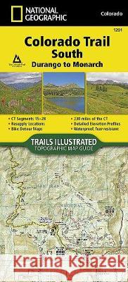
- Waterproof - Tear-Resistant - Topographic MapThe Colorado Trail, South Topographic Map Guide has been designed as the perfect traveling companion when navigating the southern section of The Colorado Trail. In a state known for its trails, The Colorado Trail is Colorado's premier long distance trail. Conceived in 1973 and completed in 1987, the trail runs 486 miles between Denver and Durango, traversing some of the most spectacular scenery in the state. When The Colorado Trail is traversed from its southern teminus outside of Durango it climbs steeply into the San Juan Mountains where it stays above 10,000 feet for almost 150 miles with only a single steep decent to the Animas River near Silverton. The highest point on the trail is found in the San Juan Mountains at 13,271 feet. After leaving the San Juan Mountains, the trail travels for a short time below 10,000 feet before once again climbing into the Sawatch Range and joining The Colorado Trail North and Collegiate Loop. Each page is centered on the trail and overlaps with adjacent pages so there is little chance of getting lost. Along the bottom of each page is a trail profile that shows the distance between passes, camping areas, and trail access points. The map and trail profile provide a step by step visual guide to hiking the trail, mile by rugged mile.Expertly researched and created in partnership with local land management agencies including The Colorado Trail Foundation, this map guide provides detailed topographic maps, interesting history, bike detour maps, and a resupply location chart shows distances, and services available at each resupply point.More convenient and easier to use than folded maps, but just as compact and lightweight, National Geographic's Topographic Map Guide booklets are printed on "Backcountry Tough" waterproof, tear-resistant paper with stainless steel staples. A full UTM grid is printed on the map to aid with GPS navigation.

  • Map Scale = 1:75,000
  • Folded Size = 4.25" x 9.38"

Kategorie:
Turystyka
Kategorie BISAC:
Travel > Maps & Road Atlases (see also Reference - Atlases, Gazetteers & Maps)
Travel > United States - West - Mountain (AZ, CO, ID, MT, NM, NV, UT, WY)
Travel > Special Interest - Hikes & Walks
Wydawca:
National Geographic Maps
Seria wydawnicza:
National Geographic Trails Illustrated Map
Język:
Angielski
ISBN-13:
9781566956949
Rok wydania:
2017
Numer serii:
000764086
Ilość stron:
44
Waga:
0.09 kg
Wymiary:
23.37 x 10.41 x 0.25
Oprawa:
Other
Wolumenów:
01
National Geographic Maps - Trails Illustrated Founded in 1915 as the Cartographic Group, the fir... więcej >


Udostępnij

Facebook - konto krainaksiazek.pl


Opinie o Krainaksiazek.pl na Opineo.pl

Partner Mybenefit

Krainaksiazek.pl w programie rzetelna firma Krainaksiaze.pl - płatności przez paypal

Czytaj nas na:

Facebook - krainaksiazek.pl
  • książki na zamówienie
  • granty
  • książka na prezent
  • kontakt
  • pomoc
  • opinie
  • regulamin
  • polityka prywatności

Zobacz:

  • Księgarnia czeska

  • Wydawnictwo Książkowe Klimaty

1997-2025 DolnySlask.com Agencja Internetowa

© 1997-2022 krainaksiazek.pl
     
KONTAKT | REGULAMIN | POLITYKA PRYWATNOŚCI | USTAWIENIA PRYWATNOŚCI
Zobacz: Księgarnia Czeska | Wydawnictwo Książkowe Klimaty | Mapa strony | Lista autorów
KrainaKsiazek.PL - Księgarnia Internetowa
Polityka prywatnosci - link
Krainaksiazek.pl - płatnośc Przelewy24
Przechowalnia Przechowalnia