• Wyszukiwanie zaawansowane
  • Kategorie
  • Kategorie BISAC
  • Książki na zamówienie
  • Promocje
  • Granty
  • Książka na prezent
  • Opinie
  • Pomoc
  • Załóż konto
  • Zaloguj się

Allagash Wilderness Waterway South Map » książka

zaloguj się | załóż konto
Logo Krainaksiazek.pl

koszyk

konto

szukaj
topmenu
Księgarnia internetowa
Szukaj
Książki na zamówienie
Promocje
Granty
Książka na prezent
Moje konto
Pomoc
 
 
Wyszukiwanie zaawansowane
Pusty koszyk
Bezpłatna dostawa dla zamówień powyżej 20 złBezpłatna dostawa dla zamówień powyżej 20 zł

Kategorie główne

• Nauka
 [2949965]
• Literatura piękna
 [1857847]

  więcej...
• Turystyka
 [70818]
• Informatyka
 [151303]
• Komiksy
 [35733]
• Encyklopedie
 [23180]
• Dziecięca
 [617748]
• Hobby
 [139972]
• AudioBooki
 [1650]
• Literatura faktu
 [228361]
• Muzyka CD
 [398]
• Słowniki
 [2862]
• Inne
 [444732]
• Kalendarze
 [1620]
• Podręczniki
 [167233]
• Poradniki
 [482388]
• Religia
 [509867]
• Czasopisma
 [533]
• Sport
 [61361]
• Sztuka
 [243125]
• CD, DVD, Video
 [3451]
• Technologie
 [219309]
• Zdrowie
 [101347]
• Książkowe Klimaty
 [123]
• Zabawki
 [2362]
• Puzzle, gry
 [3791]
• Literatura w języku ukraińskim
 [253]
• Art. papiernicze i szkolne
 [7933]
Kategorie szczegółowe BISAC

Allagash Wilderness Waterway South Map

ISBN-13: 9781566955874 / Angielski / Folded / 2020 / 2 str.

National Geographic Maps
Allagash Wilderness Waterway South Map National Geographic Maps 9781566955874 National Geographic Maps - książkaWidoczna okładka, to zdjęcie poglądowe, a rzeczywista szata graficzna może różnić się od prezentowanej.

Allagash Wilderness Waterway South Map

ISBN-13: 9781566955874 / Angielski / Folded / 2020 / 2 str.

National Geographic Maps
cena 57,46 zł
(netto: 54,72 VAT:  5%)

Najniższa cena z 30 dni: 57,46 zł
Termin realizacji zamówienia:
ok. 16-18 dni roboczych
Bez gwarancji dostawy przed świętami

Darmowa dostawa!

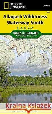
- Waterproof - Tear-Resistant - Topographic MapExpertly researched and created in partnership with local land management agencies, National Geographic's Trails Illustrated map of Allagash Wilderness Waterway South provides an unparalleled tool for exploring this majestic 92-mile-long ribbon of rivers, lakes, ponds, and streams that winds through the heart of the North Maine Woods. This map is loaded with valuable information such as watercraft regulations, rules for recreational use and access, river difficulty scale, checkpoints, visitor and ranger station locations, and more. Some of the key areas of interest included are Eagle, Chesuncook, Chamberlain, Allagash, Caucomgomoc, Moosehead, and Seboomook lakes; Gero Island; Bear Mountain; Big Reed Forest Reserve; St. John Pond; and Big Spencer Mountain.Year-round activities abound in the region and the location of boat launches, canoe carry downs, scenic viewpoints, lookout towers, and other points of interest are clearly marked as are park and forest boundaries and access points. Campers will appreciate the attention paid to noting the variety of camping facilities available including primitive campsites, group campsites, campgrounds, picnic areas, restrooms, parking, and trailheads. Whether paddling the Northern Forest Canoe Trail, camping in the North Maine Woods, or driving the Maine Scenic Byway, this map performs as a highly functional travel tool that is as useful as it is remarkably crafted. The map base includes contour lines, shaded relief, and elevations for summits and many lakes.Every Trails Illustrated map is printed on -Backcountry Tough- waterproof, tear-resistant paper. A full UTM grid is printed on the map to aid with GPS navigation.Other features found on this map include: Caucomgomoc Lake, Chamberlain Lake, Chesuncook Lake, Eagle Lake, Seboomook Lake.

  • Map Scale = 1:63,360
  • Sheet Size = 37.75- x 25.5-
  • Folded Size = 4.25- x 9.25-

Kategorie:
Turystyka, Atlasy i mapy
Kategorie BISAC:
Travel > Maps & Road Atlases (see also Reference - Atlases, Gazetteers & Maps)
Travel > United States - Northeast - New England (CT, MA, ME, NH, RI, VT)
Travel > Special Interest - Hikes & Walks
Wydawca:
National Geographic Maps
Język:
Angielski
ISBN-13:
9781566955874
Rok wydania:
2020
Numer serii:
000358694
Ilość stron:
2
Waga:
0.09 kg
Wymiary:
23.5 x 10.41 x 1.02
Oprawa:
Folded
Wolumenów:
01
Dodatkowe informacje:
Wydanie ilustrowane
National Geographic Maps Founded in 1915 as the Cartographic Group, the fir... więcej >


Udostępnij

Facebook - konto krainaksiazek.pl


Opinie o Krainaksiazek.pl na Opineo.pl

Partner Mybenefit

Krainaksiazek.pl w programie rzetelna firma Krainaksiaze.pl - płatności przez paypal

Czytaj nas na:

Facebook - krainaksiazek.pl
  • książki na zamówienie
  • granty
  • książka na prezent
  • kontakt
  • pomoc
  • opinie
  • regulamin
  • polityka prywatności

Zobacz:

  • Księgarnia czeska

  • Wydawnictwo Książkowe Klimaty

1997-2025 DolnySlask.com Agencja Internetowa

© 1997-2022 krainaksiazek.pl
     
KONTAKT | REGULAMIN | POLITYKA PRYWATNOŚCI | USTAWIENIA PRYWATNOŚCI
Zobacz: Księgarnia Czeska | Wydawnictwo Książkowe Klimaty | Mapa strony | Lista autorów
KrainaKsiazek.PL - Księgarnia Internetowa
Polityka prywatnosci - link
Krainaksiazek.pl - płatnośc Przelewy24
Przechowalnia Przechowalnia